

OUR GLOBAL IMPACT
REAL PROJECTS, REAL CHANGE
We're excited to announce our current groundwater projects and new collaboration opportunities for those who want to help shape sustainable water solutions worldwide. Let's work together to create a future with resource sustainability.

Breakfast
Ideas
Underground Caverns with TEM2Go
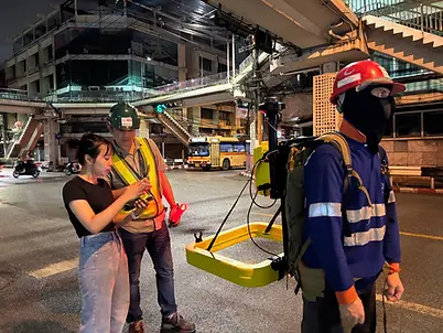
AGS Team to Support Search & Rescue in Laos
June 16, 2026
The incident occurred after seven villagers went to collect forest products and dig for gold ore in the cave before experiencing continuous heavy rain. As a result, sudden flooding and mudslides blocked the entrance to the cave, as well as flooding inside the cave, which is about 340 meters long, leaving a total of 7 people trapped in the cave.
The project team has implemented two types of geophysical survey technologies, namely TEM2GO (Transient Electromagnetic) and ERT (Electrical Resistivity Tomography), which are survey techniques that rely on measuring the electrical properties of soil and rock layers. to analyze underground structures. Find cavities, caves, and groundwater flow routes.
Another Day, Another Survey
Assess the Potential of Shallow Groundwater "in the Tungkula Weeping Field"
May 26, 2026

This operation is a geophysical survey combined with the storage of survey line coordinates with the UTM system to input the data into the process of geological and geophysical analysis and processing before being prepared as a map. Cross-sectional images and summary reports of survey results to study the condition of soil layers, sediment layers, and aquifers, as well as to analyze the storage and flow potential of groundwater in agricultural areas. aquifers and potential locations for the development of groundwater resources more clearly and accurately.

How Deep is the River?
Geophysical Survey "Mekong River Navel", Bueng Kan Province
May 12, 2026
This survey aims to study the geological characteristics of the river, soil layer, and underwater geology to assess the geological structure and potential of groundwater resources in the area.
The survey results showed that the navel point of the Mekong River is about 70 meters away from the multi-purpose pavilion next to the temple, and it is a deep hole with a diameter of about 48 meters and a depth of about 42 meters, with the water level on the day of the survey being about 10 meters lower than the bank.

Geophysical Exploration with TEM2Go
Surveys for Khong Suphan Buri Province underground water bank
Feb 15, 2026
This survey was conducted with a road tracker. TEM2Go (Transient Electromagnetic) Geophysics To collect data on geological conditions and the potential of groundwater layers. The data obtained will be analyzed and used to plan the development of water reservoirs in the form of underground water banks (open systems) to suit the conditions of the area.
Enhancing Plant Harvesting Technology
CNH Joins Hands with Chumphae Model
Dec 10, 2025
This discussion focuses on support and developing agricultural technology, tools and machinery suitable for the experimental plot area of the "Chum Phae Model, Solve Diversity, Solve Drought, and Reduce Poverty". Starting with Phase 1 of 300 rai and planning to expand to 5,000 rai in Phase 2 to lay the foundation for efficient soybean production. Reduce costs and increase productivity for farmers in Khon Kaen province.


Breakfast
Ideas
Combating the drought!
Explore 8 water sources and lay the foundation for community water management
Nov, 26,2025
The survey uses road measurements with theTEM2Go (Transient Electromagnetic) by walking around the water source to analyze the potential of the soil and groundwater layers and use it to plan the development of the community's water system.
Water Management Project in collaboration with Kasetsart University
A case study in Bang Poo Area, Samut Prakan Province and Samsen Road Bangkok
Oct, 31, 2025
The survey was conducted in collaboration with Osthai Company Geophysical Consultants (Thailand) Co., Ltd. To study the changes in soil layers and underground cavities. In addition, the working group also visited the area. Samsen Road, Dusit District, Bangkok, where the which has occurred sinkhole incident, Survey changes and moisture of the soil layer near the plumbing line. Assess the leakage of pipes in the area of the Purple Line MRT station and check to prevent road collapse in the construction area. This may cause a sinkhole in the future. This operation has been cooperated by Mass Transit Authority of Thailand the team from the project and geophysical survey experts from Kasetsart University worked together.
The results of this activity will be used as information for planning guidelines to prevent and solve the problem of sinkholes in risky areas, as well as guidelines for the development of underground plumbing monitoring systems to be safer and more efficient.
Partners


